Update: December 26, 2014
Seems like a cyclone is imminent in the Bay of Bengal. Earlier forecasts by leading weather models had said the system would at best be a deep depression. We too were sceptical about a cyclone brewing in the Bay of Bengal in mid winter. But latest forecasts say other wise. May be we are staring at the possibility of a tropical cyclone in the next 72 hours. Climate change? Perhaps.
It is generally agreed by reliable forecast models that the system 95B that hovers presently near Sri Lanka will intensify on December 29-30 into a tropical cyclone. In the next few days the storm is going to go around in a circle. Go south first then curve east, then north then westwards towards the coast of Tamil Nadu. At that point on December 30, 2014, it will intensify into a cyclone. The central minimum pressure (Which is an indicator of how strong a storm is: Hurricane Wilma had a central pressure of 882 mb) will drop into the 990s from the 1002-1004 mb levels.
After that opinions differ. The GFS says it will travel a few hundred kilometers from the Indian east coast and head to Bangladesh. The European model agrees more or less, only it says it will be a weaker storm. The US Navy's NAVGEM Model is the most bullish on 95B. It gives a central pressure of 993 and the strongest wind speeds. It says the cyclone will move in the Bay of Bengal and hit Andhra coast on December 31, 2014.
It seems Mother Earth wants to start the new year with a bang.
Whatever happens the expected tropical storm is not going to be in the league of Phailin, Hudhud or even Nilofar. One can hardly expect a super cyclone in the Bay of Bengal in December. But it might throw out winds of around 80 kph or more. And of course it is going to be a rain-maker. Depends on how it goes. Sri Lanka is getting a deluge right now because of 95B.
In conclusion, we feel system 95B will turn into a tropical cyclone in the next three days, when it is near the coast of Tamil Nadu, but it will start weakening as it ascends the latitudes and experiences the colder waters of the Bay. The moot point is will the IMD christen the storm when it is at its strongest on December 29-30 or will 95B remain an unnamed "deep depression"?

A latest satellite image of 95B taken at 0500 hours GMT, December 26, 2014. (Image Courtesy: NOAA)

The latest track path forecast of Storm 95B. The yellow line is the path prediction by the Canadian GEM Model. The other two are the forecasts by GFS and US Navy's NAVGEM Models.

This chart predicts the intensity of Storm 95B. The forecast is by AVNO, an offshoot of the GFS Model. The expected wind speeds are given in Knots. I knot = 1.85 kilometers per hour (Kph). The chart says the system will turn into a cyclone after 72 hours when its winds will exceed 64 kph.
 The IMD remains bearish on chances of a cyclone. It seems we will have to be satisfied with a "deep depression".
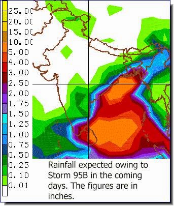 Rainfall Prediction Map: How much rain is Storm 95B (Ashobaa?) going to bring and where in the next 8 days?


No comments:
Post a Comment